-and-
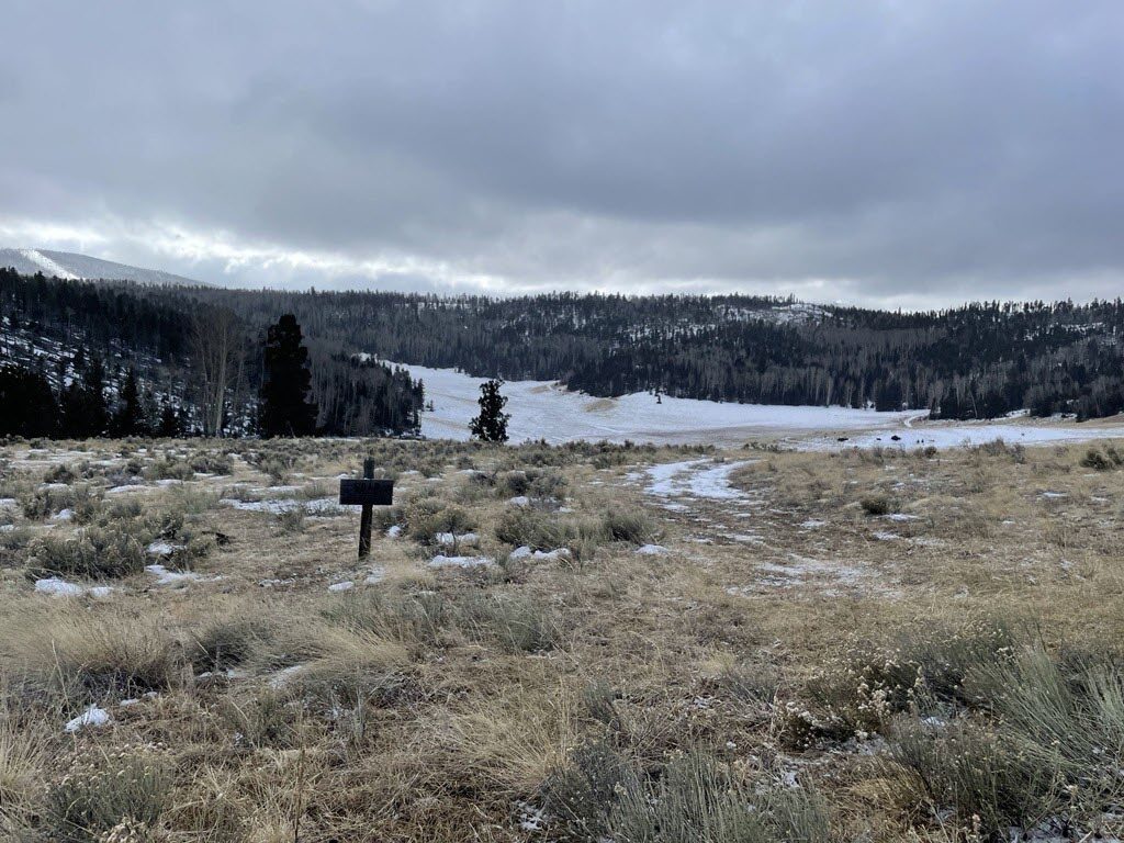
Sparse mid-season snowpack in the vicinity of the Hematite Park Manual Snow Course in the Sangre de Cristo Mountains on January 29th, 2025. The survey recorded 0.6 inches of Snow Water Equivalent [SWE] at this location, representing just 19 percent of normal.
Source: USDA Natural Resource Conservation Service
By Jaz Ammon
NRCS Photo By Jaz Ammon: Courtesy
The latest Water Supply Outlook Report is now available.
From the Summary:
“February 1 snowpack conditions are far from optimistic for New Mexico’s forecast basins, with persistent dry conditions pervading the state as we move deeper into the winter season. Extremely low to absent snow conditions dominated the state’s major river catchments as of the end of January, with accumulated Snow Water Equivalent dropping to or below the record lows in many locations. Poor winter snow coverage has left the aggregated statewide Snow Water Equivalent totals at a mere 55% of the reference period normal conditions for this time of year. A relatively smaller departure below normal Snow Water Equivalent characterized the northernmost Rio Grande Headwaters which feed New Mexico’s mainstem Rio Grande from Southern Colorado. In contrast to last month, the San Juan basin has now joined all other NRCS forecast basins further south in faring far worse, with 50% of the reference period normal Snow Water Equivalent accumulation or below recorded in these areas. These dismal winter hydrometeorological conditions point toward the possibility of a statewide record low snowpack for New Mexico’s 2025 winter season if the observed trend since the onset of the accumulation season persists into the coming weeks. With the normal peak for Snow Water Equivalent occurring in mid-to-late March in New Mexico, the next month’s winter conditions will play a crucial role in determining water availability stored on the landscape as snow for the spring runoff season.

Water year to-date total precipitation dropped below 2024 values for the state in late January. Wetter than normal conditions prior to the onset of winter have contributed to a slightly more optimistic picture of statewide total water cycle input conditions than that provided by snowpack measurements alone as of February 1, 2025. The dry conditions which became prevalent in early December have characterized the entire winter season through January, resulting in statewide cumulative precipitation as a percent of median dropping to 74% of the reference period normal on February 1. This represents a slight departure below recorded February 1 water year-to-date precipitation in 2024. While total precipitation accounts for both rain and snowfall captured across the NRCS monitoring network, rainfall early in the water year during the fall season interacts with spring runoff volumes differently than accumulated water sitting on the landscape surface as frozen snow available for melt. As dry winter conditions have persisted, the robust fall precipitation inputs seen in October and November have been overshadowed by a lack of snow water accumulating during the winter season. Such conditions leave little new water available for melt and runoff in the spring and early summer when many of New Mexico’s water users rely on surface water supplies most heavily.
Reservoir storage volumes again showed a significant increase over last year’s totals in the Pecos system for February 1, with more marginal increases over last year’s storage in the Canadian and Rio Grande Headwaters systems. The Pecos and Rio Grande Headwaters systems held at or above the reference period median “normal” storage volumes as of the beginning of February. The Lower Rio Grande, Rio Chama-Upper Rio Grande and San Juan storage systems held less water in storage on February 1 compared to last year.
This being the second official NRCS volumetric forecast publication of water year 2025, it paints a more refined picture of water supply expectations than the preceding January 1 forecasts. While forecast skill tends to increase as the corresponding forecast period approaches, these projected volumetric flow outcomes still reflect significant future weather uncertainty to come until streamflow is delivered to each forecast point in question. The forecasts provided in this report are based upon observed hydrometeorological conditions as of the end of January 2025. As such, February 1 official NRCS streamflow forecast volumes generally represent a relatively wide range of possible flows and will not account for any weather which has occurred throughout the state since the end of the last month. The notably wide range between the exceedance probability bounds in many of these forecasts reflect the considerable remaining uncertainty in how the winter will progress, and largely occur in the lowest volume waterways throughout the state. With low volumes of new hydrometeorological input and the resultant remarkably meager snowpack persisting so late into the water year, even small-scale future weather events may have a proportionally high impact on forecast outcomes moving forward.””


