It’s not often that the Library has a chance to acquire a portolan chart — an early nautical map, hand drawn on animal skin, that explorers used to navigate the seas. Not many still exist, so the Library leaped at the chance last fall to acquire a circa 1560 portolan depicting the North American East Coast by Portuguese cartographer Bartolomeu Velho.
Source: Library of Congress
Article by: Wendi Maloney
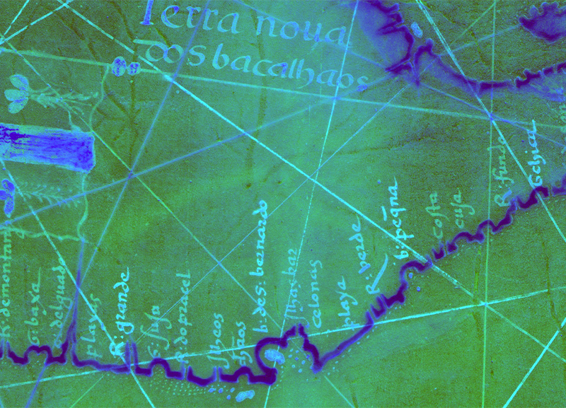
Extending from the coastline of what is now Texas, around the Gulf of Mexico to Florida then up the entire present-day East Coast, the original map and a high-resolution enhanced version, produced by the Preservation Research and Testing Division, are now on the Library’s website. The latter reveals previously illegible place names — including some of the earliest known uses of names by European explorers for locations on the Atlantic coast. The enhanced map, producing by multispectral imaging, illuminates things that the human eye cannot see. It’s the first time the Library has posted a PRTD-enhanced image.
“It’s exciting,” Fenella France, PRTD’s chief, said of the web availability of the image. “It is now a resource for scholars from anywhere.”

It required coordination between two Library’s divisions — Geography and Map and PRTD. PRTD’s work, said G&M cartographic acquisitions specialist Robert Morris, “added even more value to what was already a valuable chart.”
For more than 15 years, PRTD has used noninvasive techniques, chief among them multispectral imaging, to glean information from Library collection items that the human eye cannot see. Multispectral imaging involves digitally photographing an object at multiple wavelengths. Through imaging and subsequent processing of the data it generates, PRTD can obtain information about inks or colorants used in an object, for example, or detect a watermark that helps to date it. In some cases, an ink may almost melt away, revealing another ink below.
“It provides more information than our eyes can perceive because the camera can see in ultraviolet, and the camera can see in infrared,” said Meghan Hill, a PRTD preservation science specialist.


Most famously, multispectral imaging at the Library confirmed in 2010 that Thomas Jefferson scrawled the word “citizens” over “subjects” in the rough draft of the Declaration of Independence to describe the people of the fledgling United States.
In the years since, PRTD has imaged hundreds of Library holdings using increasingly sophisticated instruments and techniques.
In this case, Morris asked PRTD to examine it in advance of purchase — PRTD often images prospective acquisitions to confirm (or not) that they coincide with the information vendors provide.
“I asked PRTD to verify that nothing was anomalous for a mid-16th-century chart,” Morris explained. “If there had been inks, for example, not used during the period, it might indicate doctoring.”
PRTD found nothing inconsistent with the vendor’s description but noted extreme fading of iron gall ink on certain areas. PRTD agreed, should G&M purchase the portolan, to do further processing of imaging data to enhance details. Morris was particularly interested in the place names along the coast, many too faded to discern.
Typical of charts of its kind, the portolan features toponyms, or place names, set at an almost perpendicular angle to the coast and limited geographical detail beyond the coast.
Once G&M purchased the chart, PRTD initiated in-depth analysis.
“The actual imaging might take a day,” France said. “It’s the processing to pull out the information that can take a couple of weeks or longer.”
Using specialized software, PRTD applies different hues, called false colors, to different components in an object and brings forward certain components while diminishing others. The team draws on techniques that complement multispectral imaging — infrared, reflectance and the X-ray fluorescence spectroscopy.
Infrared analysis provides data about the substrate of an item — parchment, for example — while reflectance spectroscopy gives rise to details about color components within the visible spectrum, including plant-based materials. X-ray fluorescence spectroscopy offers information about trace metals in pigments, such as copper, iron or mercury.
“Essentially, what we’re doing is using different types of light to identify materials,” Hill said.
These techniques showed not only place names that had been illegible, but a scale, numbers and flags of European claimants to regions.
“Processing made them pop out more, made the details more visible,” Hill said.
Scholars mine such details, Morris said. “Place names, for example, can be used for dating,” he explained. “And when they are referenced beyond cartography, they can verify that people were at a certain location.”
The Velho portolan made its way to the Library by way of a circuitous route, to say the least.
It was found in 1961 — roughly 400 years after its creation — at Rye Castle Museum in Sussex, England. By then, however, the entire chart was no longer intact, having been cut into quarters and repurposed for its vellum, or animal skin.
The segment the Library purchased — the upper-left quadrant — was used to bind a 17th-century English manuscript before being identified as a portolan and separated from the book, according to Portuguese cartography experts Armando Cortesão and Avelino Teixerada Mota.
The Rye Castle Museum holds another quadrant of the chart. The two others “appear to be lost to mankind,” Morris said.
When the Philip Lee Phillips Society, G&M’s donor group, heard that the Library was considering purchasing the portolan last year, the society’s board quickly voted to contribute, Morris said.
Already, scholars are researching the chart, drawing on the rich details PRTD uncovered. Morris knows of at least one major article scheduled to publish within the year.


